The char dham pilgrimage is one of India’s most sacred journeys, covering four holy shrines in Uttarakhand. This guide explains the Char Dham yatra by road with detailed routes, maps, distances, travel sequence, and practical planning tips to help pilgrims complete the journey safely and comfortably.
Introduction
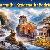
The char dham pilgrimage holds immense spiritual significance for millions of devotees across India. Nestled in the Himalayas, the four shrines Yamunotri, Gangotri, Kedarnath, and Badrinath are believed to cleanse the soul and guide devotees toward spiritual liberation.
While helicopter services are available, many pilgrims prefer the char dham yatra by road for its deeper connection with nature, flexibility, and the opportunity to visit scenic towns along the way. Road travel allows pilgrims to move at their own pace and truly experience the landscapes of Uttarakhand.
This blog offers a comprehensive road-travel guide, including the Char Dham map, route sequence, distances, and practical planning insights for a smooth pilgrimage.
What is the Char Dham Pilgrimage
The char dham pilgrimage refers to visiting four sacred Hindu shrines located in the Garhwal region of Uttarakhand. Each dham represents a different spiritual element and is associated with important Hindu beliefs.
Pilgrims traditionally follow a fixed char dham yatra sequence, starting from Yamunotri, then Gangotri, followed by Kedarnath, and finally Badrinath. Following this order is believed to enhance the spiritual merit of the journey.
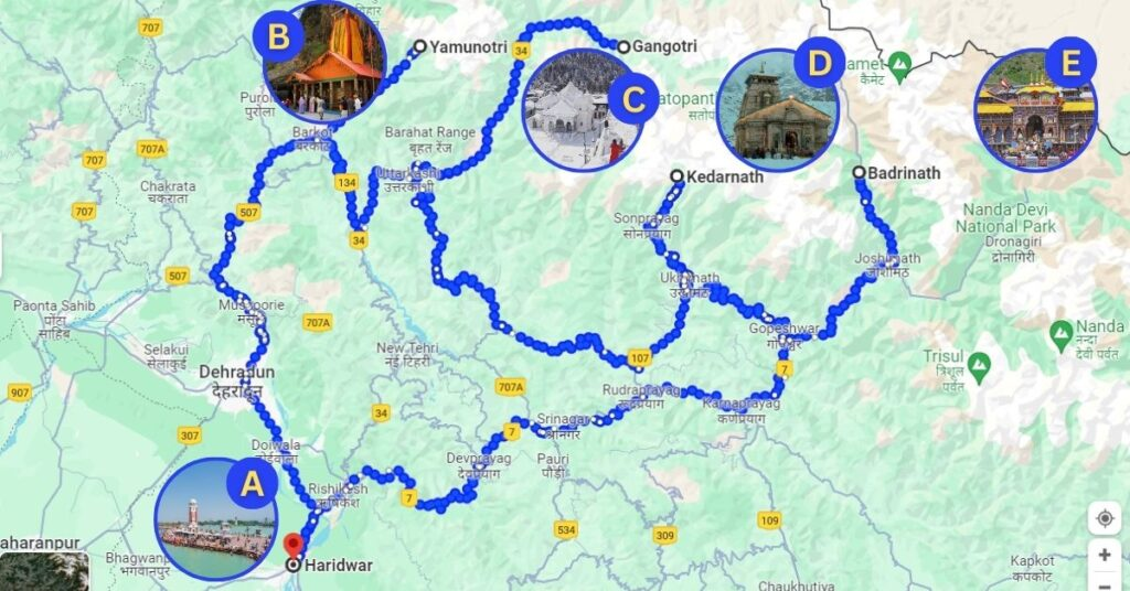
Seeing the char dham on map helps pilgrims understand how the shrines are spread across mountainous terrain and why route planning is essential.
Char Dham Yatra Map and Geographic Overview
A clear char dham yatra map is crucial for road travel planning. The shrines are located in different valleys, connected by winding mountain roads. The Uttarakhand Char Dham map highlights how the yatra covers a large geographical area, making distance and travel time important factors.
Using a char dham yatra map with distance helps pilgrims estimate daily travel limits and plan overnight stays. Road conditions vary depending on altitude and weather, so visualizing the char dham uttarakhand map beforehand reduces unexpected challenges.
The Char Dham Yatra Sequence
According to Hindu tradition, the Char Dham Yatra sequence must follow a clockwise direction (Parikrama). The pilgrimage begins from the West and moves towards the East.
- Yamunotri: Dedicated to Goddess Yamuna (West).
- Gangotri: Dedicated to Goddess Ganga (North).
- Kedarnath: Dedicated to Lord Shiva.
- Badrinath: Dedicated to Lord Vishnu (East).
Most pilgrims start their journey from Haridwar or Rishikesh, the twin gateways to the Garhwal Himalayas.
1. Leg One: Haridwar to Yamunotri
The Seat of Goddess Yamuna
The first stop on your Char Dham route map with distance is Yamunotri, the source of the holy Yamuna River.
Route Breakdown:
Haridwar → Rishikesh → Dehradun → Mussoorie → Barkot → Janaki Chatti → Yamunotri
- Distance: Approx. 220 km drive + 6 km trek.
- Time Required: 2 Days.
Detailed Journey:
The journey usually begins early in the morning from Haridwar. The road takes you through the scenic hill station of Mussoorie. A key stopover is Barkot, a quaint town that serves as the base camp for Yamunotri.
From Barkot, you drive to Janaki Chatti, the last motorable point. From here, the real test begins—a 6 km steep trek to the Yamunotri temple. You can walk, hire a pony, or use a palanquin (doli).
- Key Pitstop: Kempty Falls (Mussoorie) for breakfast.
- Road Condition: The Char Dham road map here is mostly good, but the stretch from Barkot to Janaki Chatti can be narrow and prone to landslides during monsoons.
2. Leg Two: Yamunotri to Gangotri
The Origin of the River Ganges
After paying obeisance to Yamuna, the Char Dham Yatra route moves north towards Gangotri.
Route Breakdown:
Barkot → Uttarkashi → Harsil → Gangotri
- Distance: Approx. 210 km.
- Time Required: 1-2 Days.
Detailed Journey:
You will backtrack from Janaki Chatti to Barkot and then head towards Uttarkashi, a major town on the banks of the Bhagirathi River. Uttarkashi is often called the “Kashi of the North” and is home to the famous Kashi Vishwanath Temple.
From Uttarkashi, the drive to Gangotri is mesmerizing. You pass through Harsil, a valley often compared to Switzerland for its apple orchards and pine forests. The road ends directly at the Gangotri temple, meaning there is no difficult trek involved here, making it the most accessible shrine on the Char Dham Yatra map.
- Key Pitstop: Gangnani hot water springs. Taking a dip here before heading to Gangotri is a ritual for many.
- Road Condition: The roads are generally wide and well-maintained by the Border Roads Organisation (BRO), offering a smooth drive on this leg of the Char Dham Yatra by road.
3. Leg Three: Gangotri to Kedarnath
The Abode of Lord Shiva
This is the longest and most arduous part of the Char Dham Yatra route map with distance. You are moving from the Bhagirathi valley to the Mandakini valley.
Route Breakdown:
Gangotri → Uttarkashi → Srinagar → Rudraprayag → Guptkashi → Sonprayag → Gaurikund → Kedarnath
- Distance: Approx. 270 km drive + 16 km trek.
- Time Required: 3 Days.
Detailed Journey:
The drive involves crossing multiple mountain ridges. You will pass through Rudraprayag, the confluence of the Alaknanda and Mandakini rivers. The base for Kedarnath is usually Guptkashi or Phata.
Vehicles are allowed only up to Sonprayag. From there, you must take a local shuttle to Gaurikund, the start point of the trek. The 16 km trek to Kedarnath is steep and high-altitude.
- Key Pitstop: Tehri Dam, a massive engineering marvel you can view en route if you take the Chamba path.
- Road Condition: The Char Dham Uttarakhand map shows this route is prone to heavy traffic jams, especially near Guptkashi. The trek path is paved but demands high physical fitness.
4. Leg Four: Kedarnath to Badrinath
The Seat of Lord Vishnu
The final leg of the Char Dham pilgrimage takes you to Badrinath, nestled between the Nar and Narayan mountain ranges.
Route Breakdown:
Kedarnath → Guptkashi → Rudraprayag → Karnaprayag → Joshimath → Badrinath
- Distance: Approx. 210 km drive.
- Time Required: 1-2 Days.
Detailed Journey:
After trekking down from Kedarnath, you return to Rudraprayag and then head towards Karnaprayag (confluence of Pindar and Alaknanda rivers). The route climbs up to Joshimath, the winter seat of Lord Badrinath.
From Joshimath, it is a short but steep drive to the Badrinath temple. This is the only Dham that is part of both the Chota Char Dham and the major India-wide Char Dham circuit.
- Key Pitstop: Vishnuprayag, the first of the Panch Prayags on the Alaknanda River.
- Road Condition: The road near Joshimath can be subsidence-prone (sinking zones), so it is vital to check the latest Char Dham road map updates before traveling.
Char Dham Yatra Map with Distance: Quick Reference Chart
To help you plan better, here is a consolidated Char Dham Yatra distance chart starting from Haridwar.
| From | To | Distance (Approx) | Mode |
| Haridwar | Barkot | 190 km | Drive |
| Barkot | Janaki Chatti | 45 km | Drive |
| Janaki Chatti | Yamunotri | 6 km | Trek |
| Yamunotri | Barkot | 51 km | Trek + Drive |
| Barkot | Uttarkashi | 80 km | Drive |
| Uttarkashi | Gangotri | 100 km | Drive |
| Gangotri | Guptkashi | 290 km | Drive |
| Guptkashi | Gaurikund | 30 km | Drive |
| Gaurikund | Kedarnath | 16 km | Trek |
| Kedarnath | Joshimath | 180 km | Trek + Drive |
| Joshimath | Badrinath | 45 km | Drive |
| Badrinath | Rishikesh | 300 km | Drive |
Char Dham Yatra by Road: Essential Tips for 2025
Navigating the Char Dham on map looks simple, but the ground reality involves unpredictable weather and rugged terrain. Here are expert tips for a smooth journey:
1. Best Time to Visit
The Yatra opens on Akshaya Tritiya (usually April/May) and closes on Bhai Dooj (October/November).
- May-June: Pleasant weather but heavy crowds.
- September-October: Best for scenic views and fewer crowds.
- Avoid July-August: Monsoon season brings landslides and road blocks.
2. Acclimatization is Key
The Char Dham route takes you to altitudes above 11,000 feet. Do not rush. Take a day to rest at locations like Guptkashi or Joshimath to let your body adjust to the thin air.
3. Medical Preparedness
Carry a comprehensive medical kit. Essential items include painkillers, anti-nausea medication, bandages, and portable oxygen cylinders, especially for the Kedarnath trek.
4. Registration
Registration is mandatory for all pilgrims. You must register on the Uttarakhand Tourism portal to get your Yatra e-pass. Police verification checks are common along the Char Dham road map.
5. Vehicle Check
If driving your own car, ensure it has high ground clearance. The Char Dham Yatra route has stretches of “kaccha” roads. Getting your brakes, clutch, and tires checked before the trip is non-negotiable.
Conclusion
The char dham pilgrimage by road is a journey of faith, patience, and devotion. With proper planning, a clear char dham yatra map, and understanding of the char dham yatra route, pilgrims can complete the journey safely and meaningfully.
For travelers seeking a well-organized and reliable road pilgrimage experience, Bisht and Tours and Travel Company offers trusted support, local expertise, and comfortable travel arrangements to help you focus fully on the spiritual purpose of the yatra.
FAQs
Q1: What is the total distance of the Char Dham Yatra by road?
The total driving distance for the Char Dham Yatra route starting and ending in Haridwar/Rishikesh is approximately 1,600 km. This usually takes 10 to 12 days to cover comfortably.
Q2: Which Dham should I visit first according to the Char Dham sequence?
According to Hindu scriptures, the correct Char Dham Yatra sequence is clockwise: Yamunotri first, followed by Gangotri, Kedarnath, and finally Badrinath.
Q3: Is the Char Dham map accurate for driving?
While Google Maps is helpful, network connectivity is poor in the Himalayas. It is highly recommended to carry a physical Char Dham road map or download offline maps. Drivers from Bisht and Tours and Travel are well-versed with the routes without relying on GPS.
Q4: Can I complete the Char Dham Yatra in 5 days?
Completing the full Char Dham pilgrimage by road in 5 days is physically exhausting and unsafe due to the terrain. A 5-day itinerary is only possible if you use helicopter services for Kedarnath and rush through the others. A standard road itinerary requires minimum 9-10 days.
Q5: What are the road conditions on the Char Dham route in 2025?
The All-Weather Road Project (Char Dham Pariyojana) has significantly improved the Char Dham yatra route map with distance. Wide double-lane roads are now available on major stretches. However, the last few kilometers near the shrines (like Janaki Chatti and Gaurikund) can still be narrow and rough.
Q6: Is it safe to drive my own car on the Char Dham Yatra route?
Yes, but only if you are an expert at hill driving. The roads involve steep gradients, blind curves, and heavy traffic. For a stress-free journey, hiring a local taxi service like Bisht and Tours and Travel is safer and more convenient.